Grandview Overnighter
Route Guide
Location
Grand Canyon - South Rim, Arizona, USA
Physical Difficulty*
4/10
Days to Ride
2 - 3 Days
Technical Difficulty*
4/10
Length
87 Miles
Tire Size
Recommended: 2.2"-2.6"
Seasons
Best: Late-Apr.- Early-June
Best: Sept. - October
Possible (But Hot): Late-June - August
Not Possible: November - Mid-April
Elevation Gain
4,386 Feet
Primary Surfaces
Rough Gravel; Smooth Gravel; Pavement
*Based on Bikepacking Roots’ Route Rating Scale
2. Route Description
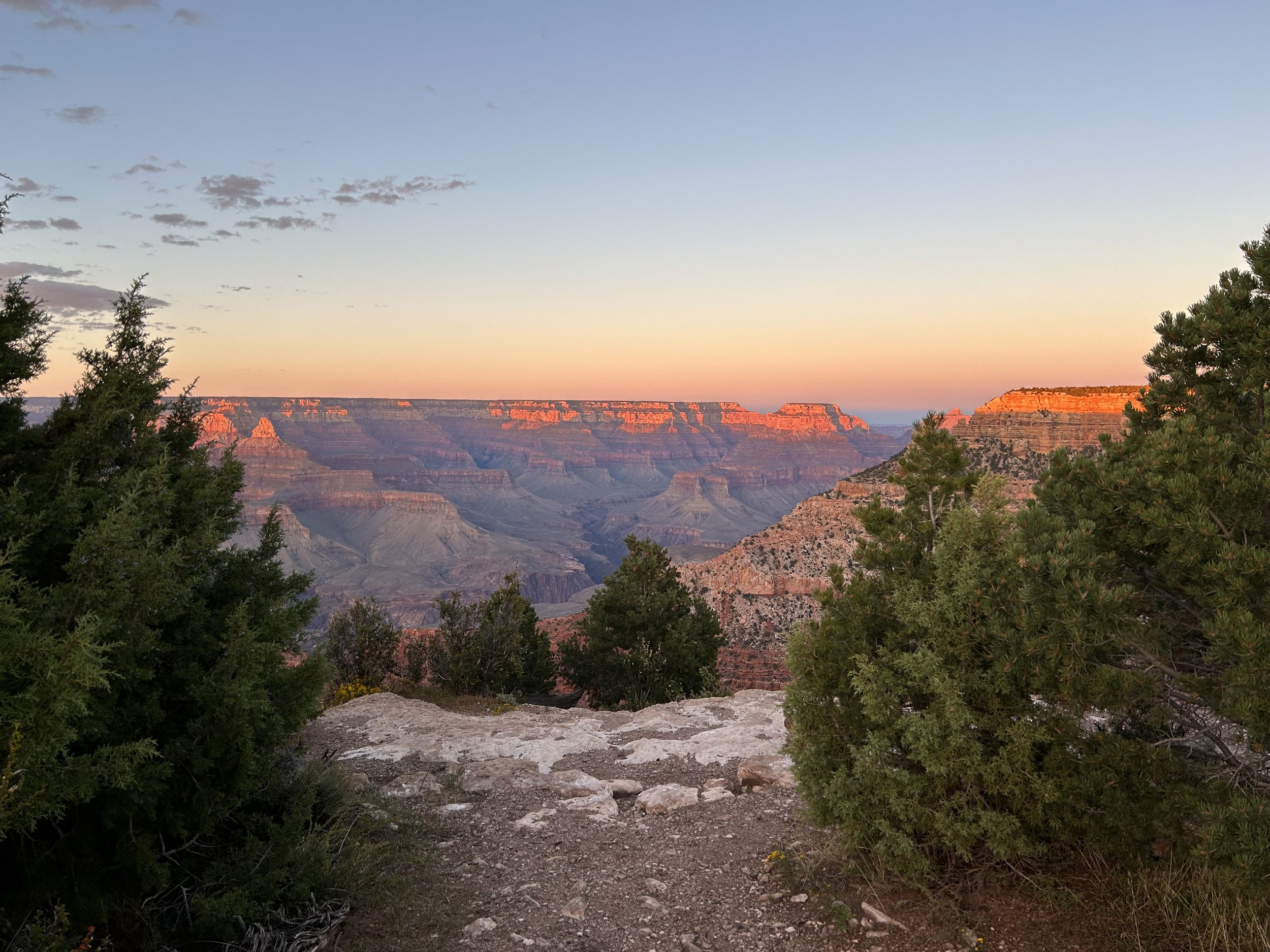
Grandview Overnighter travels down wide dirt roads into the forested heart of the Baaj Nwaavjo I'tah Kukveni Natonal Monument before looping along pavement and greenways past viewpoints of Grand Canyon National Park on the South Rim.
Riders start the loop in Tusayan where well maintained dirt roads climb gradually into large ponderosa forests that blanket the South Rim. Grasses intermix with pinyons, junipers, and oaks as riders approach the Coconino Rim in the Baaj Nwaavjo I'tah Kukveni National Monument. From here, bikepackers climb to the high point on the South Rim at Grandview Lookout Tower which sits at 7500 feet in elevation. Those who climb the tower get tremendous views north into the Grand Canyon as well as south into dense forests with distant mountains. Riders join pavement along the East Rim Drive as they pass by a number of viewpoints of the chasm. Stopping in South Rim Village provides overnight sleep at the hiker/biker site at Mather Campground before a morning push along Hermit Road where cyclists only share the pavement with buses. After several iconic views of the Grand Canyon, bikepackers rejoin dirt at the Abyss for a fun descent down towards Bright Angel Wash along Rowe Well Road. Riders take dirt roads through woodlands once more before joining with the paved multi-use greenway that carries cyclists back to Tusayan.
Highlights:
Viewpoints of the Grand Canyon including Grandview, Thor’s Hammer Overlook, Twin Overlooks, Duck on a Rock, Shoshone, Yaki, South Kaibab, Pipecreek Vista, Mather, Yavapai, Village Viewpoint, Trailview Overlook, Maricop, Powell, Hopi, Mohave, The Abyss, Monument Creek Vista, Pima, and Hermit's Rest
Climbing historical Grandview Lookout Tower and enjoying its commanding views of the Grand Canyon
Opportunities to explore Arizona Trail singletrack along the Coconino Rim
Riding road along Hermit Drive with no cars save for buses
Checking out Visitor Centers and museums in the South Rim Village
Pedaling in the shade of vast ponderosa pines in the Baaj Nwaavjo I'tah Kukveni National Monument
Loads of well-maintained dirt roads for fast and fun riding
3. Map and GPX
-
Purple = Improved Dirt Surface (Frequently Maintained, Usually Smoother)
Red = Rugged Dirt Surface (Infrequently Maintained, Typically Rougher/Rockier)
Yellow = Hiking Trail (must park bike and hike/walk)
Blue = Vehicular Pavement
Green = Paved Bike Path


4. Route Difficulty, Surface Conditions, and Direction to Ride
Route Difficulty
Physical Difficulty = 4/10 (Regular rolling terrain with sustained climbing)
Technical Difficulty = 4/10 (Track has occasional obstacles and steep sections (e.g., maintained forest roads, mellow singletrack); suitable for beginner riders with some off-road experience)
The technical difficulty of the route is due to the abundance of maintained forest service roads along the route.
The physical difficulty is mostly due to the climbing. Most of the route is found on the regularly rolling terrain of the Coconino Plateau that stretches between Flagstaff and the South Rim. Riders can expect to climb and descend regularly across hills and drainages.
Noteworthy Climbs
The climb to Grandview Lookout Tower along the Coconino Rim
Surface Conditions
Grandview Overnighter sticks to a mix of forest service dirt roads, large swaths of pavement, multi-use greenway, and some doubletrack. Dirt roads out in the Baaj Nwaavjo I'tah Kukveni National Monument and along the Coconino Rim are relatively smooth and broad. The doubletrack that leaves the rim at The Abyss can be rocky and chunky until it merges with Rowe Well Road.
The paved portions of the route that start at Grandview and continue to the South Rim Village have little shoulder but are frequently used by cyclists. Be defensive, wear bright colors, and use flashing lights. Motorists will definitely be looking at the Canyon, but they tend to drive slowly along East Rim Drive. All road riding along Hermit Drive is closed to personal vehicles, but make sure to pull over for any passing buses.
If any rain/snow is forecast, most of the unpaved route will become peanut butter/death mud and impassable in places. Leave No Trace and avoid riding at these times until the route dries out. In addition, flash flooding from precipitation is a possibility in washes or low areas - stay safe and stay out of those locations during monsoon rain dumps.
Noteworthy Vehicular Pavement
All of Highway 64/East Rim Drive: This is a long stretch of highway pavement with little shoulder, hills, and curves. It stretches from Grandview all the way to the South Rim Village. There is very little shoulder along most sections. Wear bright colors, ride defensively, and have a flashing light. This stretch of pavement is frequented by cyclists and is a part of the official Grand Canyon Connector by the Adventure Cycling Association. Luckily, most of the viewpoints/parking areas require side-spur-roads meaning people will likely be keeping their eyes on the road while driving. There are lots of pull-outs and parking areas for you to get off the road for breaks, views, and capes too.
South Rim Village: Mostly short spurts along a road with lots of traffic but good lines-of-sight. You quickly are on and off this road in-between sections of paved bike path.
West Rim Drive to Hermit's Rest: No cars are allowed for the majority of the year save for shuttle buses. Cyclists frequently ride this awesome stretch of tarmac that features some of the best capes of the route. Plus, there is a paved greenway that you can jump on for part of the ride. By Park policy, cyclists MUST dismount and get their bodies and bikes off the road and onto the sides when a bus is passing - this is for the safety of the buses and you. Be courteous and do so.
Direction to Ride
The route is intended to be ridden in a counterclockwise direction.
5. Parking
The route is intended to be ridden in a counterclockwise direction. Park your car for the duration of the route at the Grand Canyon Visitor Center - IMAX in Tusayan, AZ. Park in the back of the building in the paved parking area, but not on the adjacent gravel lot. Make sure to check into the Visitor Center with your (a) car make, (b) car model, (c) license plate number, and (d) expected return date; just let them know you're riding the COTC. If the center isn’t open, leave a note on your dashboard saying, “Bikepacking the Capes of the Canyon Route - Expected return date XX/XX/XXXX." The Center is open seven days a week from 9 am - 6 pm.
6. Water and Food
Water Reliability
Water is scarce along this route. The Kaibab National Forest is considered the driest national forest in the United States. Although the South Rim receives an average of 15.56 inches of moisture a year, most quickly percolates through the porous rock of Kaibab Limestone that makes up the upper layers of this area. Within the canyon, water exits through numerous springs, but up on top, it's a dry area. Plan to carry several liters of water, sometimes enough to last at least 24 hours and more than you think you'll need should you arrive at a source and find it dry.
Definite water can be found at South Rim Village and Hermit's Rest in Grand Canyon National Park. Beyond that, water is mostly found in dirt cattle tanks, metal cattle tanks, and Arizona Game and Fish Water Catchments (Wildlife Tanks). Wildlife tanks can be chock full of bugs and algae in the summer, but are safe to drink with treatment/purification. AZGFD Wildlife Tanks help provide water to wildlife in the ever-drying environment of the southwest under climate change. There is no camping within 0.25 miles of AZGFD Wildlife Tanks (or other water sources). This route requires riders to dry camp.
Food Resupplies
Food resupplies are located at several spots within the South Rim Village and out at Hermit's Rest.
7. Fees and Permits
Kaibab National Forest and Baaj Nwaavjo I’tah Kukveni National Monument has no fees.
Grand Canyon National Park requires a fee for entry. No cash, credit/debit only. ($35 for a vehicle; $20 for a bicycle).
8. Important Information
Hunting Season:
Starts in September and goes through December. Hunters will mostly be seeking deer and elk. Expect to see more trucks, backcountry campers, ATVs, and individuals on foot. WEAR ORANGE and make yourself visible as you ride. Be smart and be seen during hunting season. Wildlife Tanks may have more hunters scoping them out.
Dark Skies:
Grand Canyon National Park is an International Dark Sky Park. This means that you can expect to have anywhere between Bortle Class 1 - 3 night skies overhead (even better night viewing during a new moon). The Bortle Class Scale is used to rate night skies on their clarity and lack of light pollution. A Bortle Class 1 is the darkest possible and there are several locations along these routes where, should you camp, you will have this level of darkness. Here, night skies will be virtually unimpeded by artificial light. You can use the following sites to explore more:
Black Bears:
There are black bears which means you need to properly store your food at night using a bear-aware method.
ATVs:
ATVs are somewhat common around the Coconino Rim and Grandview Lookout Tower. Outside of here, ATVs are much more rare across the Coconino Plateau, although you will see them. However, I have found drivers are pretty respectful, will check on you/offer you water, and give you space when passing.
Fences:
There may be "cowboy fences" on this route which consist of barbed wire wrapped around vertical wooden branches that are strung across roads. They can be opened by removing a loop of wire on one side. Most importantly, leave fences as you found them; re-close them if they were closed.
Hantavirus and Plague:
Bubonic plague and hantavirus are frequent enough amongst the rodent population that you should avoid their saliva, feces, urine, and direct bodily contact. Be careful when entering old cabins and caves where droppings are plentiful and ventilation is limited. These are prime areas for possible contraction of these diseases.
9. General Access and Tribal Nations
Bikes are STRICTLY forbidden below the rim in the inner gorge of the Grand Canyon. DO NOT RIDE YOUR BIKE DOWN INTO THE CANYON - you will get fined, it is illegal, and you will hurt the perception and opportunities of other bikepackers on this route. There are certain trails on top that are also off-limits to bikes; this route expressly avoids them. No cross-country travel in Grand Canyon National Park; practicing Leave No Trace means staying on established trails, roads, and paths.
Finally, respect tribal land and do not ride without permission in the Navajo Nation. This route stays explicitly within land domains where riding is public and legal. Although it may approach boundaries with the surrounding tribal nations, you should never ride onto the reservations without securing tribal government permission. Doing so otherwise is disrespectful and unlawful. I must note that although this route stays on "public lands," the formation of Grand Canyon National Park involved the forced removal of the Havasupai, and they have endured legal battles to keep their vastly smaller chunk of land out of their historical precedent. Know the land you are riding on is traditionally theirs, know their current reservation boundaries are smaller than where they historically inhabited, and know where you are riding to keep yourself both legal and respectful.
10. Camping
There is no dispersed camping within the boundaries of Grand Canyon National Park. Mather Campground in Grand Canyon Village has a fantastic hiker/biker site for walk-ups arriving by foot or bicycle. The hiker/biker site is shared with other cyclists and backpackers and costs $6 per night per person. Mather Campground is conveniently located next to the Post Office (M - F, 8 - 3:30 pm), the General Store, the Public Library, Yavapai Lodge + Tavern, and a bus stop.
Outside of GCNP in the the Baaj Nwaavjo I'tah Kukveni National Monument/Kaibab National Forest, excellent and numerous dispersed camping abounds. Make sure to pay attention to boundary lines between the National Monument and Grand Canyon National Park.
11. Sample Route Itinerary
This is a suggested itinerary. Use it as a rough guide for your own planning purposes. Feel free to use it, adapt it, or don't use it all and make your own plans. Plan your trip on this route based on your own strengths, comfortabilities, experiences, wants, and needs.
-
Mileage: 39 Miles
Elevation Gain: 2200 Feet
Water: Wildlife Tanks
Resupply: None
Camping: Dispersed Camping near Grandview Tower (ride down the AZT a little towards Watson Tank for more camping solitude)
-
Mileage: 20 Miles
Elevation Gain: 700 Feet
OPTIONAL: Combine Days 2 and 3 and cover 48 miles and 2200 feet of gain to finish.
Water: Water Faucet at South Kaibab Trailhead; South Rim Village
Resupply: Canyon Village Market & Deli (General Store)
Camping: Hiker/Biker site in Mather Campground
-
Mileage: 28 Miles
Elevation Gain: 1500 Feet
OPTIONAL: Combine Days 2 and 3 and cover 48 miles and 2200 feet of gain to finish.
Water: South Rim Village, Hermit's Rest, Tusayan
Resupply: Tusayan
Camping: Finish! Stay at Tusayan-Montane Campground outside of Tusayan, grab a hotel, or dispersed camp in the woods.